
Startsida justus.ownit.nu |
Flight |
beacon in Mariehamn |
(Airports (Sw.) ) |
Mariehamn Airport, Ĺland
EFMA Mariehamn Airport - in early years
Contents: Sea airport. Land airport 1937- map/air-photo. History. Old Photos. NDB-beacons. Links.
In this webpage we have collected some early maps and photos from Mariehamn airport, and a text on its history.
Material from FlightForum.fi, Finavaia.fi, and a book on Mariehamn's history.
Fig. 1. At first there was a sea airport in Mariehamn, in its eastern harbour at island Lilla Holmen.
The earliest air traffic service to Mariehamn was in 1928, with a Junkers F-13.
At that time there were sea airports in Stockholm/Lindarängen, and Turku/Ruissalo,
and Helsinki/Katajanokka.
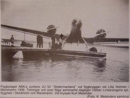
Photo from a book on "Mail service in Ĺland during 350 years" (in Swedish) by Jari Karhu, Torsten Wikstrand, 1988.
Around 1936, the first land airports were built in Finland and in Sweden;
Turku/Artukainen 1935, Stockholm/Bromma 1936, Helsingfors/Malmi 1936.
Then, Mariehamn too needed a land airport and its construction started in 1937, a few chilometres west of the town.
It had grass field - very common in those years - and air services started in 1940 with aircrafts DC-2 and Junkers Ju-52.
Maps and air photo from time of construction, around 1937
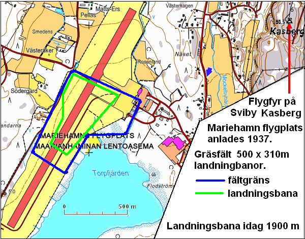
Fig. 2. Map showing the air field a few chilometre west of town center, copy via Pekka Paajasen, FlightForum.fi
Small circles indicate the outline of the field area: rajamerkki = border-mark (lamps?)
The landing area had size 500 x 310 m.
Arrow with text: "1 km kallio kork 68 m" = 1 km hill height 68 m (=air beacon's altitude!).
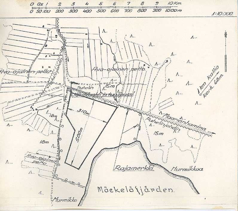
Fig. 3. Aerial photograph of the field in an early stage, 1 July 1938. No buildings by that time!
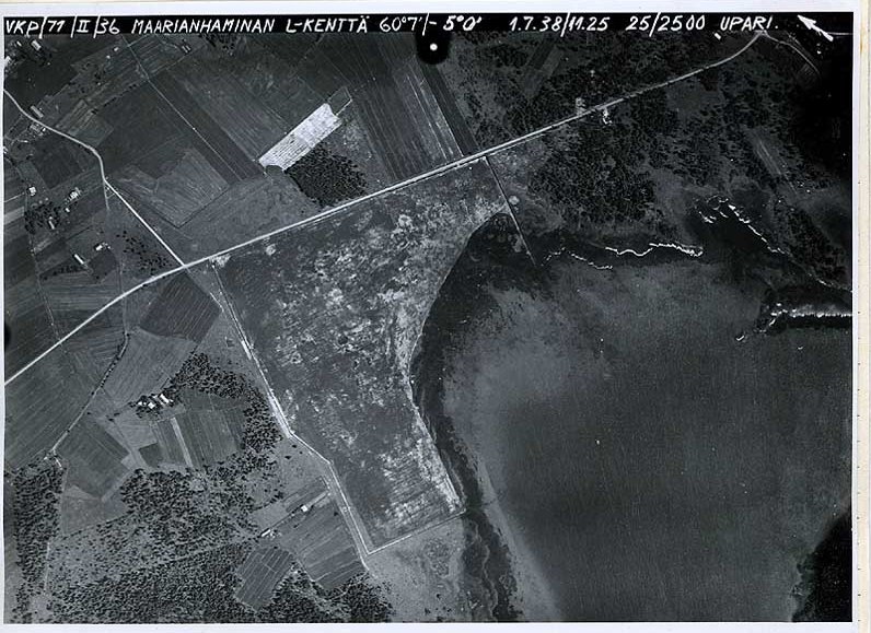
Fig. 4. Same photograph, but rotated to north, for easier comparison with maps.
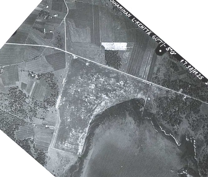
Fig. 5. Map to-day, with old field borders plotted in blue and green (by Bo Ju). Basemap is from "Maps for everybody".
Reference points are; farm Södergĺrd, road crossing north of Södergĺrd, the ditch east of the field.
Note that the shore-line has moved south due to land rising and increased vegetation.
Red arrow points to position of old air beacon. Runway to-day is 1900 metres long!
Mariehamn's history - Air traffic services
Excerpt from the book: "Mariehamns stads historia 1961-1986",
Christina Remmer, ISBN 951-98141-1-6, Mariehamn 1999, in Swedish.
It has been published as a pdf-file at Mariehamn website, free of charge
› pdf-fil, 5 MB.
Translation here by Bo Ju.
Air traffic services (pp. 73-74)
"Aviation history in Mariehamn
goes back to 1928, when city council
guaranteed a sum of 10.000 mark, which
was needed for Aero Inc. to start air traffic
to Mariehamn during a test period. However,
even though one had support from city council
and an existing interest in stops in Mariehamn
on the route Turku-Stockholm, traffic ceased in 1930.
Aircrafts used in these early services were
single-engine sea aircrafts of type Junkers F 13.
Tourism to Ĺland increased in the early
years of 1930s, and flight connections restarted.
A "flight harbour" was built at a small island in
eastern part of Mariehamn, at Lilla Holmen.
However, in 1936 the Ĺland county council decided to build
a land-based air field. This made aviation planning
on Ĺland a question for the regional county council,
although the Mariehamn city council still could give
opinions, especially on where to build the new airport.
The new airfield was placed in Jomala close to
Torpfjärden (Torp bay) and was inaugurated
in 1940. The runway was extended to 1900 metre at
the end of 1950s. For security reasons, a road that
had crossed the runway, was closed and a new road
was built in 1962 westwards along Torpfjärden
and Ramsholmen. The same year one installed
Instrument Landing Systems (ILS).
However, the new safety systems could not
prevent a severe accident in the evening
8 November 1963. One of Aero's DC-3 planes
crashed when landing from north in poor
visibility conditions. Of the onboard
passengers 21 were killed and three survived.
In 1964 flights with Super Caravelle
started, and the same autumn a new passenger
terminal opened. The airfield was extended
southwards in 1965 and the new ILS-system
was tested thorougly. |
Between 1957 and 1965, a prison institution
was stationed close to the airfield. Prisoners
made construction works under surveillance of
the Board for Road and Water Constructions.
In 1 April 1971 air traffic started with Finnair's
DC-9 aircrafts, which were used for around
10 years. The Mariehamn airport was named
"Mariehamn flygstation" (air station).
The DC-9 aircrafts were expensive to fly, especially
after the oil crisis 1973, and traffic services changed
to somewhat less comfortable planes like: Fokker,
Bandeirante and Saab SF 340.
In 11 December 1985, tax-free sales had its
"premičre" on the route to Arlanda/Sweden.
In addition to regular communications between
Finland and Sweden, Finnair's planes made extra stops
in Mariehamn once a week during tourist season
on the route Turku-Hamburg during 1964-1971.
Ĺland Trade Commerce Authority has been
very pro-active for traffic development in the Ĺland county,
through contacts with Finland country authorities.
This holds especially for maritime winter traffic
and regular air traffic, where remarkable improvements
have been made.
An Ĺland-owned flight company Skärgĺrdsflyg Ab
(~Archipelago Flight Inc) was founded in 1956. The company
has its base in Mariehamn eastern harbour district, and has
traffic in the archipelago area, with ambulance transports
and taxi- and sightseeing trips. The company has also
had severe traffic accidents. Both in 1960 and in 1970,
Cessna aircrafts crashed. In the first accident all three
onboard were killed, and in the second accident one
passenger survived."
- - -
(this historical account ends at 1986).
|
Remark: Air traffic services in Ĺland is a much-discussed political topic.
Especially the route to Arlanda/Sweden, which has to compete with the
very cheap and popular maritime ferry traffic between Sweden and Ĺland
Old photos
I have found rather few old photos from Mariehamn's airport on Internet.
Finavia.fi has a short text with two old photos. Link:
› Maarianhaminan Lentoasema, pdf, 2 pp. It is p. 88-89 from a book, see below.
Fig. 6. Earliest terminal building at Mariehamn airport. Photo from 1950s?. Part of a wing from a DC-2/DC-3?
Some radio antennas can be seen, but no direction finding antennna.
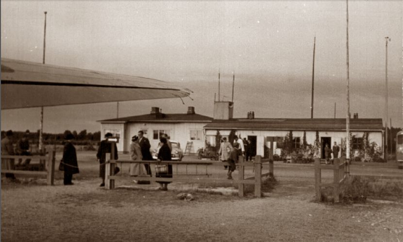
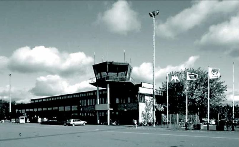
Fig. 7. Mariehamn airport. The second terminal building, opened in 1964. Photo from 1970s?
NDB and VOR radio beacons
After World War II, one established networks of NDB radio beacons (non-directional beacons)
and later also VOR beacons which could give bearing from the beacon to airplanes.
At the airport to-day, there are: VOR/DME, NDB (at north), VDF, ILS (Rwy 21), PAPI.
NDB radio beacons around Ĺland:
- FlightForum.fi is a discussion forum on Internet with lots of information for Finland.
This includes facts about air light beacons and NDB radio beacons. For example, air route maps from around 1950.
One shows radio beacons in Mariehamn(OJD) and Ĺbo/Turku(OJE), but it may have been mainly a planning map(?)
- On UtilityForuumi (http://peditio.net/utility) there is a NDB list from 1981
and many photos of old NDB transmitters.
- The closest NDB beacon in Sweden was in Vallentuna, as can be seen on maps from 1944 and 1956, but not later on.
- In early years, there were also direction finding radio equipments in Turku, Helsinki and Stockholm/Bromma.
| Place / Name | Code | Frequency kHz | Remark |
| NDBs early: |
| Mariehamn | OJD / MAR | 392 | 1949 -, now GDY below |
| Ĺbo/Turku | OJE / TUR | 361 | 1954-, now LIE below |
| Finno, on Kökar | FIN | 354 | 1960 - 1995 |
| Korso, N Helsinki | KOR | 322 | 1951 - |
| Vallentuna, Sweden | SEO | 406 / 370 | 194x - 196x, on route Red 1 |
| NDBs to-day, 2012: |
| Mariehamn, Godby | GDY | 392 | - |
| Ĺbo/Turku | LIE | 361 | - |
| Espoo, W Helsinki | ESP | 381 | 1966 - |
| Korso, N Helsinki | KOR | 322 | 1951 - |
| Erken, Sweden | ERK | 383 | - |
Links
- Mariehamn airport, Wikipedia - in English
- Remark: the corresponding page in Swedish contains much less information (April 2012).
- www.mariehamn.ax, Mariehamn town website
- under Culture there is pages on Town History and 150 Year Anniversary
-
Mariehamn airport, Finavia
› Finavia.fi - is responsible for 25 airports and flight navigation in Finland
Book for sale: "Aika matka kiitotiellä - The Finavia Story", see:
› Historiikki or
› History.
For pilot-information see links C , or use Google and search with texts like:
"AIP Aerodrome Mariehamn" or "AIP Sweden AD" - This works for many countries!
- FlightForum.fi - discussion forum in Finnish.
Air light beacons and NDB beacons have been treated extensively.
Links to pages in Finnish and also links for translations using Google Translate:
› FlightForum.fi - in Finnish and with English translations "GT:"
- with direct links to themes on light beacons: a) Norrtälje-Finland, b) Kumlinge, c) Iniö.
NDB beacon search - very much information on sites and frequencies.
- www.peditio.ner/utility, UtilityForuumi
- has a list of NDB beacons in Finland in 1981, and many photos of old and recent NDB radio transmitters.
- In Finnish, use Google-Translate on link.
Bo Justusson, Stockholm
Contact: justusXownit.nu - switch X to @
Web: justus.ownit.nu/flyg
Last update: 26 April, 2012