
Start page www.justus2.se |
Flight |
Air Navigation and Maps
Early Air Navigation Maps
1. The first strip maps (route maps)
Roller type map-holder, in which the map was moved forward by turning the roller knobs,
as the plane progressed.
- Airplane of Blķriot XI-type, most likely from Thulin's factory in Scania.
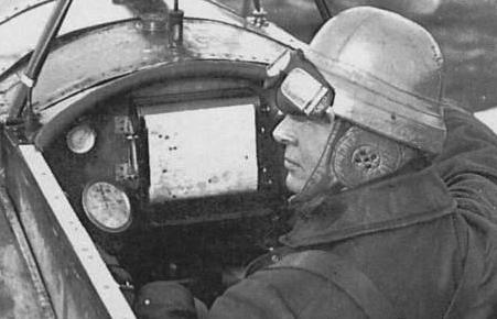
Photo from the book "Flygplan frÕn f÷rr" (Old-timer airplanes), Peter Haventon, 1989,
ISBN 91-552-2419-9. This book contains images from ┼hlķn & ┼kerlund Photo Archive at Landskrona museum. Can be found in antiquariats.
|

|
2. Swedish Air Force Route Maps, 1936 (strip maps)
In the early years of flight one recognized the need of suitable aeronautical maps for visual navigation.
One decided to use an existing map series in scale 1:300 000 and added flight information in red printing.
This map series was produced in large map sheets and covered all Sweden.
In 1936 Generalstabens Litografiska Anstalt (General Staff's Lithographic Institution)
was commissioned to produce strip maps for 11 routes in Sweden, named "Flygvapnets routekartor".
Here we display scannings of strip maps for route no. 1 and no. 4, covering the main night mail flight routes.
Aerodromes are shown with red circles ( O )
and air light beacons with red stars ( * )
Links below are marked "GE:" = Google English translation of a webpage in Swedish
- Not perfect, but often understandable!
- Use Back-button or Alt + Left_arrow, to return to this page.
GE: › General information about Swedish Air Force Route Maps
GE: › Route 1 Stockholm - J÷nk÷ping - Malm÷, large images
GE: › Route 4 Malm÷ - Gothenburg - Oslo, large images
(at present on another webserver: algonet.se)
GE: › Roller map-holders at Air Force Museum, Link÷ping
3. Route maps (strip maps) Sweden - Finland, 1930 and 1936
Swedish airline ABA and Finnish Aero co-operated around passenger flight between Stockholm and Helsinki
in "Scandinavian Air Express". Strip maps for pilots were made in scale 1:800 000,
in 1930 for seaplane routes, and in 1936 for landplane routes.
The large land aerodromes in Stockholm/Bromma and Helsinki/Malmi were both opened in 1936.
GE: › Route maps Sweden - Finland, 1930 and 1936, scanned
4. Route map Amsterdam-Copenhagen, 1935
NEW 25 March, 2012
Generalstabens Litografiska Anstalt produced several route maps around 1935 (strip maps)
› Map Amsterdam/Schiphol - Copenhagen/Kastrup, 1935
- scanned at National Air and Space Museum, in USA!
5. American Airlines Inc. - Routes, Maps ~1945
NEW 7 April, 2012
These maps show important routes, and radio beacons and light beacons along them.
Combo-map scanned by David Rumsey Historical Map Collection. Here displayed splitted by route.
› American Airlines Inc. - Routes ~1945 - 12 sub-maps!
› American Airlines Inc. - System Overview Map ~1945
› Lighted Airways Maps
- more maps for night flight lines in USA.
- Belongs to a large website with photos, coordinates, stories etc. for Flight Service Stations in USA.
6. Flight routes overview map, 1944, Air Traffic Authority
Map of flight routes, aerodromes, air light beacons, radio beacons
Most of the displayed units were in place alreadey in 1939. Click for a larger image, in a new window.
|

|
Last update 22 June, 2014, Bo Justussson, Stockholm
Contact: justusXownit.nu - change X to @