This is a short route
from Birrfeld to Bern, in Switzerland, using aerofly FS 2 sim (AFS2).
We use it to test different autopilots and instruments, from old to modern, and simple to advanced.
I made this route and webpage for my own sim-training!
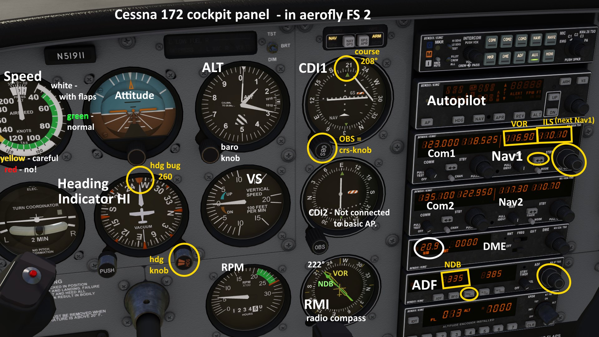
• Flight 1 in Cessna 172 with a basic autopilot, getting input from:
Horisontal indicator gyro, Altitude barometer, Nav1 radio.
• Flight 2 in Baron 58 with a HSI.
Flight 3,4,5 in next webpage:
• Autopilots Part 2: Computerized Type plus Glass Cockpit
! Comments and corrections are very welcome -
New topics for me, and I am only a sim-pilot!
• Contact, see below!
|
Fig 0. Basic autopilot for small aircrafts - Bendix King - in aerofly FS 2 and other sims
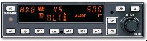
Most used buttons: [AP] = AutoPilot on/off, [HDG] = Heading, [NAV] = Nav1 VOR,
[APR] = Approach ILS, [ALT]+[ARM] = Altitude+select, [VS] = Vertical Speed [up][dn].
- Image: HDG selected, climbing VS 500ft/min to an armed ALT (not shown).
|
Catching ILS is critical.
Do settings in correct order!
It took me several landings to succeed! |
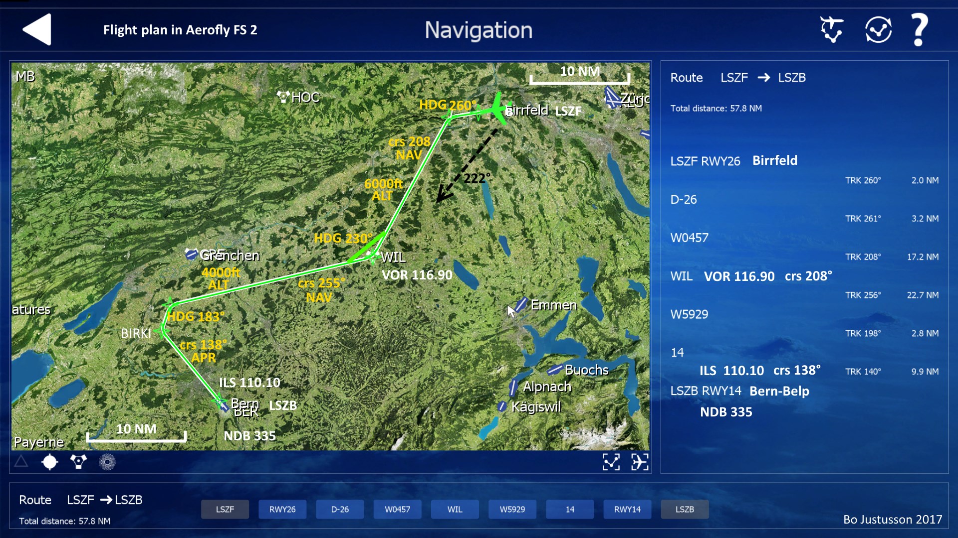
The approach to Bern has been setup by combining
instrument procedures STAR and IAC for Bern airport.
Data source: openNav.com, for sim use, see • Links
|
SID Standard Instrument Departure
(not used for this flight) |
1. NAV crs 255° from VOR WIL 160.90
2. ALT 4500ft + VS dn -600ft/min ARM
3. hdg-bug 186°. At D22.7 WIL: HDG!
4. Nav1 swap to ILS 110.10
5. crs 138° on CDI1 (and ev.HSI), then NAV!
6. when LOC crs armed, press APR and
catch glide slope (GS), from below
Also: speed Vappr, Flaps, Gear+Flaps
Max safe ILS+APR intercept angle is 30°.
CDI in NAV-mode: ±10°, each dot:2°
CDI in APR-mode: ±2.5°, dot 0.5°
Glide slope scale ± 0.7° dot 0.14°
Fig 4a. Plane on hdg 186° to catch ILS-beam 138°
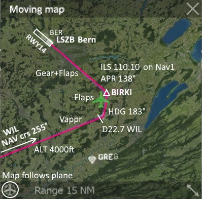
Fig 4b Pilots view in cockpit:
- Nav1 receives VOR: CDI1 shows TO-arrow and GS is not red. Beam nears from right.

|
STAR Standard Instrument Arrival Chart.
Fig 5. STAR Bern. One route is radial 255° from VOR WIL,
until D 22.7 NM from WIL, then TR186° to waypoint BIRKI. (For sim use!)

Fig 7. AD Aerodrome Chart Bern. (For sim use!)

|
IAC Instrument Approach Chart.
Fig 6. IAC ILS Rwy 14 Bern. Landing by ILS from BIRKI to Rwy14 Bern, hdg 138°, GS 4°.
(Sim use!)
- Glide slope 3° (= 5%) is more common!
- Thick dashed line shows go-around route.

|
Three images for ILS-final to Rwy 14 Bern:
Fig 6. CDI shows plane on track - both lines near center! Reduce speed and flaps + gear down!

|
Fig 7. Runway straight ahead. Plane is a little high,
glide slope is 4°, more common is 3°. More flaps!

|
Fig 8. Closing in on runway.
Setting point is 200/400m after white stripes.
Autopilot can land aircraft (in sim!)
PAPIs are not correct in AFS2 - show 3°.

|
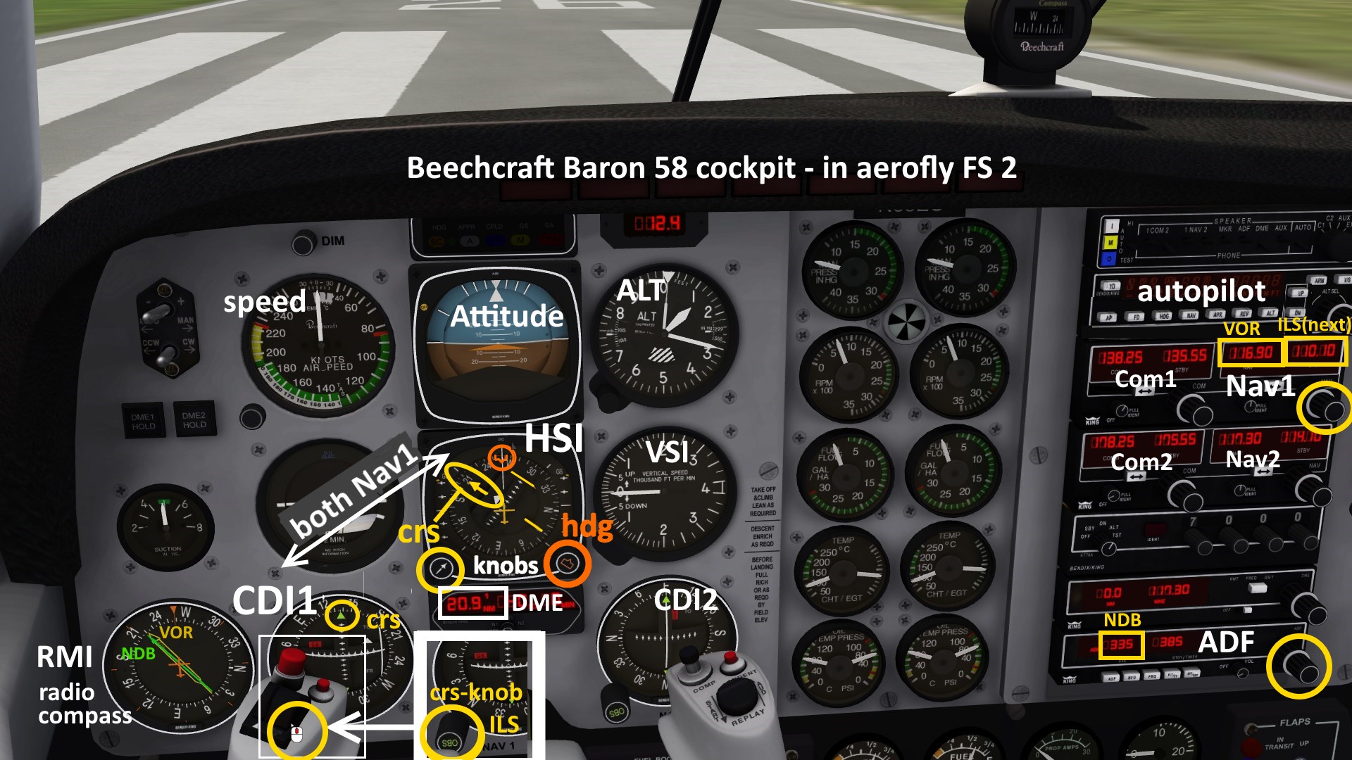
Baron 58 is twin-engined, and is both heavier and faster than Cessna 172.
First Baron came in 1961. One of the most produced small business airplanes.
Baron58 cockpit is sligthly more modern than Cessna172
in having a HSI (Horizontal Situation Indicator)
which combines gyro compass and course deviation indicator.
|
HSI Horizontal Situation Indicator, image from Wikipedia.
• HSI, Wiki

|
Speeds (V = Vitesse, fr)
Vrotate____ 85 KIAS, knots, NM/h
Vcruise____180 kts --> 3 NM/min
Vappr_____140 kts
Vref______100 kts - at threshold
Vs0_______ 74 kts - stall when flaps+gear Out
climbVS____1600 ft/min (max)
|
Pre flight settings for route no.1
VOR-navigation is simpler with HSI, more info combined!
Attitude indicator above and DME below. Same is used in glass cockpit below!
In this sim-version, Nav1-radio guides both HSI and CDI1.
- More advanced HSI let you select what to display on HSI: Nav1, Nav2, GPS, NDB.
- AFS2: The CDI1-knob is hidden behind the yoke,
but can still be set with mouse wheel!
|
Fig B1. Pre flight settings in Baron 58, in AFS2
|
Fig B2. Baron58 on ILS-beam to Rwy 14 Bern

The glide slope in HSI is shown with two yellow squares, one at each side.
I find CDI1's white line easier to read.
|
Some advice for ILS-landing:
- Set ILS course in both HSI and CDI1!
- Intercept angle to ILS-course max 45° (30°?)
to VOR max 60°(45°?) - or you risk to over-shoot.
Especially in fast jet aircrafts.
- First NAV to catch LOC-crs, then APR and get GS.
- Set flaps and Gear (F, G+F).
- Keep speed well above stall speed Vs0 = 74kts.
Vref = 1.3xVs0 ~ 100kts at threshold,
Vappr = Vref+40kts ~ 140 kts.
- Autopilot can land aircraft all the way (in sim!),
but you should flare over Rwy, and
if sidewind use rudder to line-up with Rwy.
|
Fig B3. Baron 58 on Rwy 26 at Birrfeld, in AFS2

|
Fig B4. Baron 58 above Rwy 14 in Bern-Belp at night. Calvert landing lights. Plane too high?

N.B. PAPIs are not correct in AFS2 - show 3°, should here be 4°.
|
VFR Visual Flight Rules
- Used by smaller aircraft flying at lower altitudes and in good weather.
Pilots are responsible to keep distance to each other.
For details see Wiki:
• VFR
and • IFR
|
IFR Instrument Flight Rules
- Planes shall be able to fly in dense clouds!
- Larger aircraft almost always fly by IFR.
- ATC (Air Traffic Control) is responsible for separation of aircrafts:
VFR-planes shall be at lower levels than
IFR-planes, and ATC follows each VFR flight by its transponder.
- Standardised procedures are used for start and landing:
SID, STAR, IAC,.. |
Flight variations
- Test with low clouds and at night!
Runway lights appear in "last minute".
- Test without MovingMap,
as IFR was before GPS & RNAV.
Routes were along Airways from VOR to VOR.
- Test without VOR,ILS,GPS -
only paper map, compass, NDB - as in 1930s.
|
Flight 3,4,5 in next webpage:
• Autopilots Part 2: Computerized Type plus Glass Cockpit
|