
Flight |
Air Light Beacons |
( ⇐ Sw. )
( ⇒ Sw.) |
planned beacon in Salo
Salo - A beacon was planned, but not built, Finland (F06)
Lat, long WGS84: 60.37185, 23.18245, coordinates for its planned position on a hill east of Salo
In 1936 one decided to build a route with air light beacons, and in 1937 most of it was built.
Salo was included in the original plans, but it was never built. The same holds fro Lohja/Lojo.
One alternative for the Salo beacon was in Uskela church tower, but the parish said no.
A second alternative was on a hill 3 km east of Salo, but it was not built due to WWII.
A small landing field was setup. It was i simple grass field with some markers.
Below you find some planning maps, and an overview map from 1936 which illustrates the planned route.
These facts come from a very good report from Tauno Hermola, Salo.
Report by Tauno Hermola: "There has never been an airfield in Salo before
Kiikala airfield (EFIK) became part of Salo, when
the municipalities were merged. However, the plan for the Stockholm-Helsinki air route included
some emergency landing places close to some of the beacon-towers.
The location of the emergency landing place in Salo seems to be about the same that is shown in
"Scandinavian Air Express. Air Route Map" at your webpage.
Note: the decision to build the air route was made in 1936 and was mostly completed by the end of 1937;
the information in the map must be based on some preliminary planning only. The emergency landing place in Salo
was only a little more than a field, and was indicated in the maps as suitable place for emergency landings.
Some people have recalled that there were some markings also in the terrain.
The story of the lighthouse is equally unexciting. Two possible locations were selected,
both to the South of the then very small town.
The primary location was the tower of the church of Uskela;
the alternative location was a couple of kilometers East of the church, on top of a high hill.
The plan was that the church tower also would have to be raised.
This plan was eventually rejected by the parish. Logically,
planning should have moved for the alternative location but I'm not aware of anything such.
So, there was never an aerial lighthouse in Salo."
Maps from planning of the route, and for location of the beacon in Salo
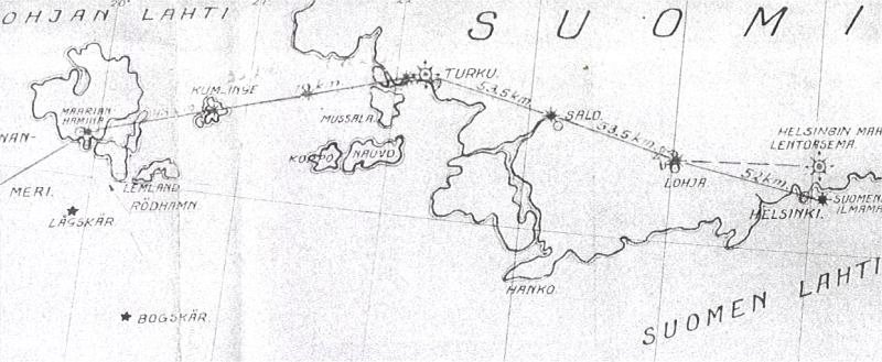
Map 1. Plan for the route with air light beacons in Finland, ~1936.
One can see that beacons were planned in both Salo and Lohja (Lojo) but they were not built.
Image via Kari Syrjänen, FlightForum.fi
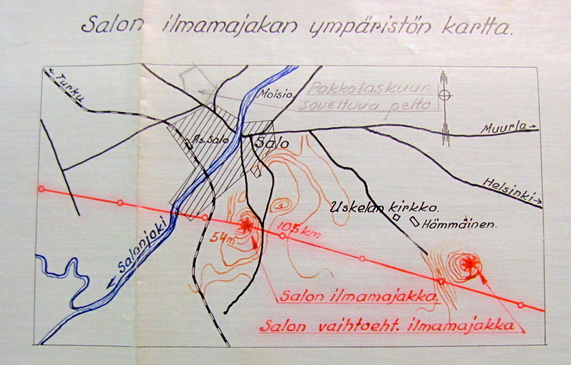
Map 2. Planning map with different alternatives for a beacon in and emergency landing field in Salo.
Image via Raine Haikarainen, FlightForum.fi
Texts in Finnish:
- at height "54m" south of Salo (=Uskela church): Salon ilmamajakka = Salo light beacon,
- at height in east: vaihtoeht. = alternative,
- at a field north of Salo: Pakkolaskuun soveltuva pelto = for emergency landing suitable field.
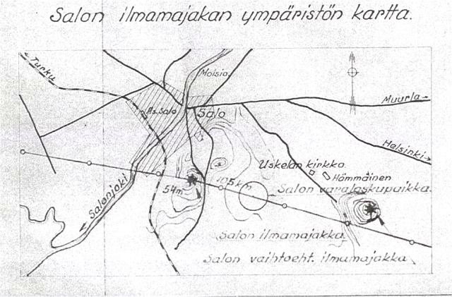
Map 3. Another planning map. Image via Kari Syrjänen, FlightForum.fi
- Text: at the circle betseen the two heights: varalaskupaikka = emergency landing place.
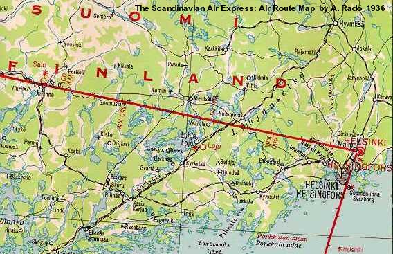
Map 4. Overview map from 1936 for the planned route.
A section of a map "Lentokartta. Air Route, Scandinavian Air Express, by Generalstabens Litografiska Anstalt (1936)"
Scanning from Pauli Kruhse webbsite with Documents for the History of Finland, see link below.
The full map is now available on my page:
› Sweden-Finland route maps, 1930, 1936 - Sw.
Note: This map was produced before the route was built, and therefore is based on the plans.
Remark: In an earlier version of this page, I wrote that this map was by A.Rado, but his map is the one from 1930!
Coordinates WGS84:
Uskela church: 60.37656628, 23.13397114
Height, east of Salo: 60.37185507, 23.18245199
Field, north: 60.39477734, 23.12962934
Field, south: 60.37560554, 23.15042421
To-day there is an airfield 25km east of Salo: Kiikala EFIK
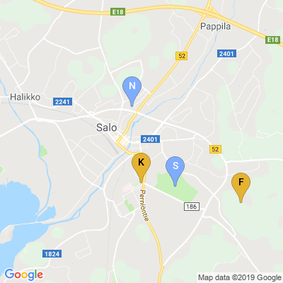
Map 5. from Maps.Google.se:
K= Uskela church, F= Height for beacon.
N= Emergency landing place, S= alternative.
|
Detailed map
Link to Finland Mapping Agency
> Salo beacon, planned but not built -
"Katplatsen - Maps for everyone"
"Kartplatsen" - has detailed maps and aerial photos in internet for Ĺland änd Finland
You can create links to maps and also convert coordinates.
Menu system in three languages: Finnish, Swedish, English.
> Legend, map markings, pdf
- with symbols and text in all three languages - good translations!
|
Links
- Feeniks aviation journal (published by Finnish Aviation Museum Association) :
- Article on the air beacon route Stockholm-Helsingfors, in Feeniks 1/2012
- Article on air beacons, also in Feeniks 4/2005.
The beacons in Finland are also called Karruksen beacons,
after captain Edvin Karrus, who supervised the building of the air route. In 1936, he was nominated
as inspector of civil aviation in the Ministry of Communications and Public Works.
- histdoc.net, Pauli Kruhse's website about the History of Finland
"History of Finland. A selection of events and documents" - with a very large collection of
documents.
- FlightForum.fi - discussion forum in Finnish.
Air light beacons and NDB beacons have been treated extensively.
Links to pages in Finnish and also links for translations using Google Translate:
› FlightForum.fi - in Finnish and with English translations "GT:"
- with direct links to themes on light beacons: a) Norrtälje-Finland, b) Kumlinge, c) Iniö.
Some Finnish words - for use in internet search!
I managed to search information also from webpages in Finnish using some fundamental words, see below.
Then Google Translate gave a translation which is reasonably understandable. Sometimes one gets very strange results,
since names of towns or persons may get translated literally!
Some Finnish words. Note that in combinations, they get bent with different endings.
Therefore, it is better to use Google in Finnish - google.fi - since it handles bending.
air beacon = lentomajakka
airport = lentoasema
airfield = lentopaikka, lentokenttä
airplane = lentokone
post = posti-
church = kirkko
Finland = Suomi
Sweden = Ruotsi
Ĺland = Ahvenanmaa
Mariehamn = Maarianhamina
Ĺbo = Turku
Runsala = Ruissalo
Lojo = Lohja
Last Updated: May 9, 2012
Bo Justusson, Stockholm,
Contact: justusXownit.nu - switch X to @.