You can use POI Flight Planner to select a sequence of points-of-interest (POI) as waypoints (WP), and then fly between them in a simulator with detailed scenery, e.g. Aerofly FS (AFS), using visual navigation. I have two goals with this little program: train visual navigation and learn more about Switzerland's geography.
I have selected POIs one can see from a plane in a simulator, e.g. towns, lakes, rivers, mountains, valleys, passes,.. AFS is based on aerial colour photos and elevation data, and gives a very good view of the landscape. You can of course use this Planner with other sims - FSX, P3D, X-Plane - if you have good add-on sceneries (like Switzerland Pro X).
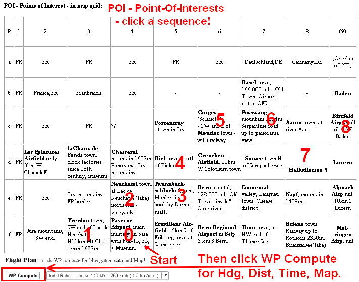
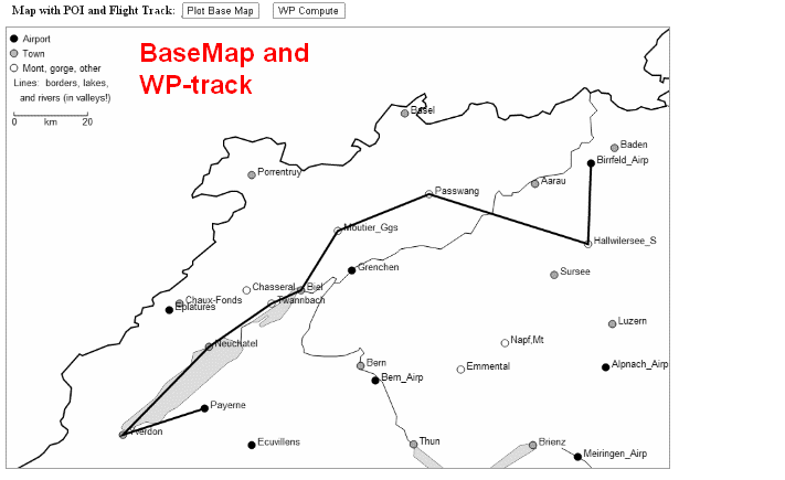
POIs are listed in a grid (map-like), and shown in a BaseMap. You select a start airport and then a sequence of POIs. The program calculates:
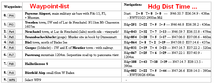
- Headings, Distances, Times, displays RWY-info, and a simple Map.
All data and program are in webpages - Switzerland NW and NE (SW, SE not ready) - and use only HTML5, so no installation is needed. I have used local spelling of place names, e.g. Schweiz, Rhein, Bodensee, Genéve, Lac Léman, Piz Ault.
• NW - Fsim_POI_Schweiz_NW.htm
• NE - Fsim_POI_Schweiz_NE.htm
Manual
1. You begin by clicking on a start airfield in POI-list or in BaseMap,
and then on a sequence of POIs, auto-added.
2. Click on Compute to get Hdg, Dist, Time, Lat Lon Alt, and a Map.
3. You can do some basic Editing: add, replace, delete WPs,
and change aircraft (cruise speed).
4. Print the flight plan to have at hand when you fly - print as HTML!
5. In simulator - Select start Airp. Fly by Headings. Look-out for POIs!
6. Topographic Maps - useful for orientation, have one at your side!
7. Timer/clock - also very useful.
More on Easy-to-see objects:
Railways can be seen in AFS. Note that in early days pilots often navigated along railway lines! - Towns can be seen, but buildings can not be recognized since air photos are taken from above. However, railway stations, stadiums, and harbours are easily spotted. - Some more:
- Gorges (Schluchten), e.g. in Jura mountains
- Rheinfall, a water fall in Schaffhausen
- Einsiedeln monestary
Topographic Maps
- You should have a good map at your side when you fly, in scale 1:200 000-600 000. Many maps are available from producers, e.g. Freytag&Berndt, Marco-Polo. Choose one with good shading of mountains, and with not too many roads.
- ICAO flight maps have lots of airspace information, scale 1:500 000
• Official Aeronautical Map of Switzerland, at Swisstopo.
- No map yet? - Try this old Tourist Map - "SBB - Urlaub in der Schweiz mit Bahn, Schiff und Postauto". It was produced for SBB by Freytag&Berndt in the 1950s-1970s, and has mountain shadings, altitudes(m), and railways in red - good for our flight sim nav since it also indicates main valleys! (QUESTION: Is this map available somewhere to-day?)
• Map Schweiz NW, jpg - in new window
• Map Schweiz NE, jpg
Click to show in full size! If you print each on an A4 page, you get scale ~ 1:600 000.
Some sample flight plans
I have made three plans and then saved them as html-files:
• Lakes and mountains in Jura region, in NW
• Along Rhein and Bodensee, in NE
• Vierwaldstättersee and south - mountains, passes. Mid
Important Link
• VFR Information package for Switzerland - at • Steam community forum
- a large collection of airport maps, approach charts,... for aerofly FS.
Last updated: 21 June 2014, Bo Justussson, Stockholm
Beta test, please send me your comments, of all kinds!
Contact: justusXownit.nu - change X to @
Main website:
• justus.ownit.nu/flyg - in Swedish, and
• English version - using Google Translate
Sample image for free POI Flight Planner
No install needed since all is done with HTML5-canvas + javascript.
1. You choose a sequnce of way-points (grids)
2. Click WP Compute button, and you get a List of Way-points, headings, distances, times
3. You also ger a simple Map. - Print all and use during flight!
3. You also ger a simple Map. - Print all and use during flight!